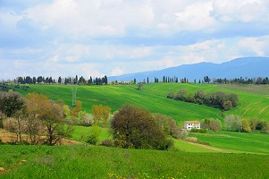


Norcia (PG) - Saturday, July 6, 2013, the Group MTB Rampichini calls for a ride (for biking tours of good technical qualities) around the Piano Grande di Castelluccio, in the middle of flowering and the magnificent scenery of the Sibillini Mountains.
Itinerary: Departure from the saddle near the Rifugio Perugia (mt 1456) along the path in the direction of the parking facilities Monti del Sole, hence always trail down to the shelter Ascoli, and then along the dirt road start to climb . At the end of the dirt road, through meadows are rapidly gains altitude and then continue along the trail to the summit of Mount Macchialta (mt 1751) the highest point of our hike. Also for path continues towards Forca di Presta, through a structure of the park, from where you can enjoy a wonderful view of the Monti della Laga, the Gran Sasso and the Carrier. Reached Forca di Presta (mt 1534) near the spring bends to the left downhill to the Pian Piccolo. By crossing the Valley of the Bonanno, keep right, crossing the Pian Grande (mt 1280) in the midst of meadows and fields. Circling then Castelluccio and going through the Pian Lost you reach the source of the Val di Canatra (mt 1360). From here you turn left, go up a steep dirt road to the intersection with the panoramic rooms Castelluccio (mt 1547) towards Poggio of the Cross, and here you will have for about 3 km, stunning views of the Pian Grande which sports. At the crossroads for the Monte Patino (mt 1743), for a fun single track that leads around Monte Ventosola and reached the ultimate source, continuing along a dirt road you get to the starting point.
Type of route: Mainly surface roads natural tracks and paths.
Distance: 38 km around
Height: m. About 900
Journey time: about 5 hours (including stops)
Water Supply: along the paths there are 4 sources
Meeting point: 6.45 am at the parking lot behind the MiniMetro
Return in the afternoon
Recommended equipment: backpack with food and water supply according to their habits and needs, repair kit tire and inner tube, Creative Commons, pump.
Tour members only
Registration: within 16 hours of Friday, July 5 at the e-mail rampichini@caiperugia.it or SMS to 3355757742
Recommendations: On stretches of open roads, both paved and dirt roads, remember to follow closely the rules of the Highway Code. And 'mandatory and essential to helmet use.